The next route in our quest to reach Cherbourg,
we move on the D 116 west from Gatteville-le-Phare. Through the villages of Roville and
Gouberville, we visit our next object, the bunkers of Néville-sur-Mer. When we reach this village,
we drive towards the coast. To find this site, we drive right of the church, and keep on this road.
After a couple of hundred meters passed the church, keep right at the fork in the road. After
some 500 meters, go left.

The battery of Néville-sur-Mer was locally known as Stp 126 Blankenese.
This battery is extreme close to the seashore, almost on the beach. Every year the sea is closing
in on the battery, and one day the erosion will swallow the battery. The Kriegsmarine (German navy)
had the command over the battery, and the 2/260 Marine Artillerie Abteilung had the responsibility.
To this day, the complex is entered at the original guard post.

The front of the M 272 casemate
of Blankenese,
Néville-sur-Mer
There a many types of bunkers and casemates in this complex to be found.
The different sort of casemates in this complex was more or less to blame on the many types
of weapons the Kriegsmarine used. From the Channel Islands some 94mmVickers M39 guns were
brought over. Two of these guns were mounted into the M 158 casemates, and a third in an M 272.
The M 272 is the first large casemate you come across and recognizable on the collapsed roof.

The rear of the M 272 casemate,
Then and Now

On June 20, 1944, the 24th Cavalry Reconnaissance
Squadron, 4th Cavalry Group, occupied Néville-sur-Mer. The American engineers started
immediately in the destruction of the site. As seen on the pictures, the managed this for a great deal.
Especially the M 272 casemate was hit hard, and the roof gave in. Behind one of the M 158 casemates,
ammunition bunker was blown apart, and the roof cart wheeled upside down a little further away.

In front, the roof of the bunker
at the rear.
A nice feature in this complex are the many concrete tunnels that connected
the bunkers and casemates. At the rear of the complex, some are still intact, but at the front,
the tunnels are smashed by the sea.

A small part of the tunnel
complex is preserved
It’s a great complex to wander around. It is fascinating to watch how the sea
the concrete away nibbles, and the battery into it’s waves pulls. The ground around the bunkers
has been swallowed already. There are many signs at the complex to warn the visitor for unexploded
ammunition. But nobody seems to care. When we visited the place, some boys were busy playing paintball.

The sea pulls onto the concrete,…
To continue our tour towards Cherbourg, return on the same
road, to the village ofNéville-sur-Mer. Turn right here, onto the D 116. After a couple of kilometers,
you reach the village of Vrasville. Some 200 hundred meters further, turn to te left, take the D 412
near Angoville-en-Saire. After 4 kilometer you come across the next interesting object. At the
crossroad with the D 901 at St. Pierre-Eglise are the remnants of a German navigation system.

Navigation system Erika 2.
(Google
Earth)
This station was; W 158, the sonstige Funkführungsanlage Erika 2. It consisted
of 6 x FuG 121 Erika Bord. The complex is split by the D 412. To the west of the road stands a
part of the foundation of an antenna, with, in a other field, an overgrown personal bunker.

One of the six foundations of Erika 2.
At the other side of the road, to the east, are five more of these foundations for
antennas. In front of every base, stand a bunker which once contained the electronics that collected
the information it received from the antennas. In the eastern field are two other huge personal bunkers.
The complex is on private property where cows stroll in the meadow, but can be seen from the road.

Go to St. Pierre-Eglise, in the centre turn right, and after
the church go left, and go onto the D 210 (also called the Rue de Calvaire) towards Fermanville. After
4 kilometers you come across an Y-dividing, keep left and go
left onto the D 116, to Cherbourg. After a kilometer go left into the
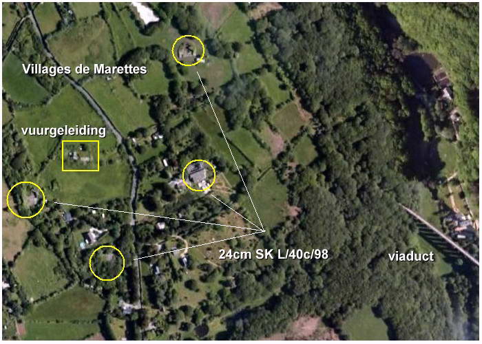
Villages de Marettes. In this region was the heaviest battery in the north of the Cotentin built by
the Germans, to protect Cherbourg.

MKB
Hamburg south of Fermanville
(Google
Earth)
MKB Hamburg had four heavy guns of 24cm SK
L/40c/98. The crew to handle and protect these guns consisted of 260 men, of
which 250 were from the 9 Marine Artillerie Abteilung which stood under command of
Oberleutnant Rudi Ernst Max Gelbhaar. Gelbhaar had given the order to tear down the
heavy concrete protected left sides of the emplacements, so the guns could fire to the rear
of the battery, from where the American troops were approaching.

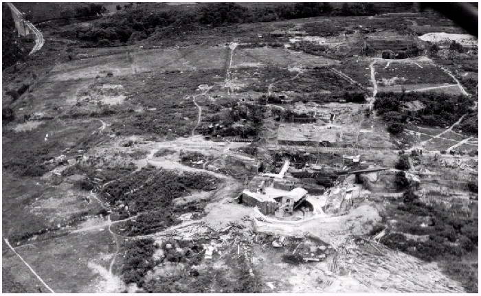
Battery
Hamburg, with in the foreground the most northern 24cm gun
You may notice the removed concrete on the left side (right on the picture)
(for a comparison with
'Google Earth'; top left the viaduct)
On June 25, 1944, a serious duel between Battery Hamburg and the
American Navy. The reach of the Hamburg guns were at least 26 kilometers, and had to
be destroyed before a run into Cherbourg, from the sea, could be done.
For this purpose the battleships USS Texas and USS Arkansas,
together with the destroyers Barton, O'Brien, Laffey, Hobson and Plunkett
Bombardment Group 2 were composed. The first ship to open fire, at 12.08 hours, on Hamburg
was the USS Arkansas.

A heavy German shell
from Battery Hamburg lands in sea
(picture taken from the USS Arkansas,
in the back, the USS Texas)
Batterie Hamburg waited untill the Group was within reach, and
then opened up at 12.29 hours. Three guns aimed at the USS Barton, but made no damage
was done (although, there was a ricochet on the hull of the ship).
The duel finished at 15.00 hours when the Bombardment Group retreated. The
USS Arkansas had fired 58 12 inch shells, and the USS Texas
fired 206 shells with their 14” guns. The USS Quincy also shot at the battery.
Of the 65 shells who were counted that landed around the USS Texas, two hit the ship.
As mentioned before, the USS Barton, was hit once, just as the USS Laffey,
which was also a dud. The USS O'Brien was struck with one shell which did detonate,
and killed 13 men, and wounded 19. werd ook geraakt.
On 28 June, Batterie Hamburg surrender to the Americans of the
4th Infantry Division. The battery is these days no longer visible, it is completely covered
in the undergrowth and behind high hedges on private land. The best way to see some of it,
is to look with ‘Google Earth' (49º40'45 50"N - 1º27'09 47"W).

USS
Nevada fires her 14” guns towards Cherbourg
Bombartment Group 1, with the battleship USS
Nevada as the most heavy one of these group, came close to Cherbourg,
and fired on the coastal batteries. But the USS Nevada was also fired upon, and some
27 fell around the battleship, but no hits where made. The USS Nevada fired 112
shells with her 14"/45 guns and 958 shells with her 5”/38 guns. All German batteries suffered
under the heavy shelling from the American ships. The next object, you can easily visit, was
pounded also.

The direction finder
and observation bunker of Batterie Seeadler
On you way ‘Villages de Marettes’, you come across
a sort of fork in the road, turn right into the Hameau Carré. After 800 meters, turn left
(just before the D 116), and keep left in the bend of the road, and turn into the Chemin
du Bruley. After a kilometer, on the crossroad straight on the Chemin de la Marine. You
entering now the sector of Batterie Seeadler.

Batterie
Seeadler (in the yellow circles the emplacements for the 17,4cm guns)
(Google
Earth)
The Batterie Seeadler was equipped with four 17,4cm guns in open
emplacements. These are still, without their guns, to be found in the heath and ferns, on a
plain called Pointe du Bruley. They can be found to the north, or right of the path that stretches
out from Chemin de la Marine. You can enter this area by a special gate to keep the cattle
inside these boundaries. The emplacements are serious big things, with personal shelters incorporated
into these emplacements.

The most eastern open emplacement of
Seeadler
But the most impressive object of Seeadler, is the observation/direction
finder bunker on the highest top. A short walk is worth the visit. If you don’t feel like walking,
return to the crossing of Chemin du Bruley and turn right. After some 500 there are more bunkers to
be found.

Another view of Seeadler,
its observation/direction finder bunker
We continue our trip on the northern coastal road,
the D 116.
To Cherbourg
CLICK BELOW ON THE DIRECTION FINDER OF
SEEADLER
|